2016.03.18 11:20
Montrey 지역 추천 코스(Fort Ord National Monument)
여기 산악회에서 한번도 안가본데 같은데 창공님 시간되실때 한번 다녀오시고 후기 좀 올려주심..
Fort Ord National Monument
Fort Ord National Monument is a former U.S. Army post located near Monterey Bay. The fort was established in 1917 as a maneuver area and field artillery target range, and was considered one of the most attractive locations of any U.S. Army post due to its proximity to the beach and California weather. In 1988, Base Realignment and Closure (BRAC) legislation was passed by Congress and three years later the decision to close Fort Ord was made. Fort Ord was officially closed in 1994, and was the largest U.S. military base to be closed at the time. On April 20, 2012, President Obama signed a proclamation designating a 14,651-acre portion of the former post as the Fort Ord National Monument.
While much of the old military buildings and infrastructure remain abandoned, many structures have been torn down for anticipated development. California State University Monterey Bay and Fort Ord Dunes State Park, along with some subdivisions, the Veterans Transition Center, a strip mall, military facilities and a nature preserve occupy the area today.
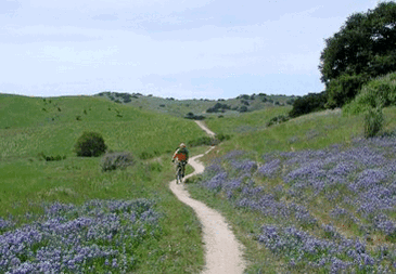
Approximately 7,200 acres of Fort Ord National Monument are currently open to the public. Prior to being opened, the land underwent a comprehensive remediation process that involved an extensive munitions clean-up. The public area currently includes 86 miles of trails that are a mix of singletrack and dirt roads. Elevations in the park range from about 100' to almost 1000', and the climbs are generally mild to moderate.
 Aerial view of Fort Ord in 1941 (from www.army.mil)
There are three main trailheads from which to access the trails in Fort Ord: the Creekside Trailhead, the Badger Hills Trailhead, and the Laguna Seca Trailhead.
The Dirt:
Extras:
The Dirt:
- Click here for the official web site.
- A printable trail map can be found here.
- Click for driving directions to: Creekside Trailhead, Badger Hills Trailhead, or Laguna Seca Trailhead via Google Maps.
Extras:
- Inside Trail Racing holds a great race here with distances ranging from 10K - 100K!
- To the best of our knowledge, there is no drinking water available in the park!
-
개인간의 카톡내용을 공개할 수도 있군요 0
-
진달래님? 4
-
The Wave!! 소개 0

-
3/26(토) 산행지 추천 받습니다. 2
-
산행정보방 1
-
아리송님께 0
-
Milpitas지역 추천 산행지.(Ed Levin County Park) 2
-
Montrey 지역 추천 코스(Fort Ord National Monument) 2
-
Saratoga Gap근처의 추천 산행지 4
-
밀어내기 신공 4
-
회원탈퇴수순 3
-
산행 정보 Sources - Internet Sites 6
-
3/19(토) 산행지관련 건의사항 3
-
MT. SHASTA 등정관련정보 9

-
창꽃님의 재가입에 대한 '정대위' 입장 3

 Milpitas지역 추천 산행지.(Ed Levin County Park)
 Saratoga Gap근처의 추천 산행지


http://www.blm.gov/publish/content/ca/en/prog/nlcs/Fort_Ord_NM.html 에서 Map보니까 엄청 넓네요. Trail Head도 세군데나 되고...