여기도 산악회에서는 한번도 안가본데 같은데.
Ed Levin County Park
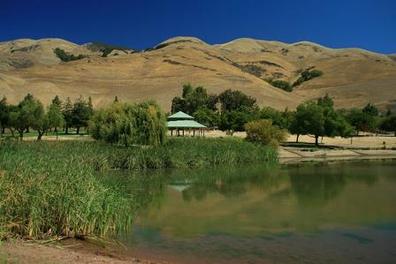
Ed Levin County Park is a unique multiple activity park located in the hills just east of Milpitas. Even though the park is located less than 20 minutes from an urban area, it offers miles of challenging trails as well as many other activities such as picnicking, fishing, and even has an off-leash dog park for Fido. In addition, the park provides several launch sites for hang gliders and paragliders.
The trails in Ed Levin are mainly fire roads that range from moderate to very steep. The elevation in the park varies from around 500' near the lake to over 2500' near the summit of Monument Peak. Because of the elevation gain, Ed Levin Park is a great place for some hill training, only minutes from the urban area. Your efforts are rewarded with great views of the Bay Area. And, the trails connect to Mission Peak Regional Preserve, so very long and challenging runs or hikes are possible by linking the two parks.
The weather in Ed Levin County Park is typically mild in the winter and hot and dry in the summer. There is very little shade in the park, so we recommend bringing plenty of water and wearing sunscreen if you attempt the trails in the summer!
All of the runs on this page start from the trailhead near the dog park by Sandy Wool Lake.
The Dirt:
Extras:
The trails in Ed Levin are mainly fire roads that range from moderate to very steep. The elevation in the park varies from around 500' near the lake to over 2500' near the summit of Monument Peak. Because of the elevation gain, Ed Levin Park is a great place for some hill training, only minutes from the urban area. Your efforts are rewarded with great views of the Bay Area. And, the trails connect to Mission Peak Regional Preserve, so very long and challenging runs or hikes are possible by linking the two parks.
The weather in Ed Levin County Park is typically mild in the winter and hot and dry in the summer. There is very little shade in the park, so we recommend bringing plenty of water and wearing sunscreen if you attempt the trails in the summer!
All of the runs on this page start from the trailhead near the dog park by Sandy Wool Lake.
The Dirt:
- Click here to download a printable map of the Favorite Runs below!
- Click here for the official park site with trail map.
- Click here for driving directions to the trailhead near Sandy Wool Lake.
Extras:
- The only drinking water available in the park is located near the trailhead by the dog park. There is no drinking water available along the trails!
- There is a fee to enter the park.
- If you are interested in learning more about paragliding or hang gliding in the park, visit the Wings of Rogallo site.
Favorite Run #1: Monument Peak Lollypop (9.0 mi, ~2500 feet elevation gain)
This run starts at the trailhead near the dog park and takes you all of the way up to the summit of Monument Peak. The views of the Bay Area from the trails are spectacular, so bring your camera! The trails are mainly fire roads, and they can be hot, sunny, and dry in the summer so bring plenty of water! To get to the trailhead, drive past Sandy Wool Lake and follow signs to the dog park. Park in the paved lot near the dog park and look for the Tularcitos Trailhead. GPX Track Printable Trail Map Driving Directions |
Route Details:
 View from the Monument Peak Trail
- 0.0 mi: Start up the Tularcitos Trail toward Monument Peak.
- 0.2 mi: Turn left through the gate to get on the Agua Caliente Trail. You will pass through several gates and cross a few roads on your way to the peak.
- 1.6 mi: Just after crossing Monument Peak Road turn right at the cattle drinking trough onto Monument Peak Trail. You will climb steeply for a bit. If you start descending you are going the wrong way! Continue on Monument Peak Trail all of the way up to the ridge.
- 3.7 mi: At the ridge, the trail turns to a gravel road. To get to the actual summit, head past the radio tower and turn right on the next gravel road. Follow this road for a quarter-mile to the summit.
- 4.1 mi: At Monument Peak summit! After enjoying the view, retrace your route back to the intersection. But instead of heading down Monument Peak Trail, follow the signs to Agua Caliente Trail.
- 4.4 mi: Get onto Agua Caliente Trail. Get ready for some steep downhills and amazing views! You will follow the Agua Caliente Trail most of the way back to the trailhead.
- 7.5 mi: Confusing intersection! Cross Monument Peak Road and make sure to stay on Agua Caliente Trail!
- 8.8 mi: Agua Caliente Trail ends at Tularcitos Trail. Head through the gate and back to your car.
- 9.0 mi: Back at your car!!
Favorite Run #2: Ed Levin to Mission Peak (12.5 mi, ~2700 feet elevation gain)
This run combines the hill climb of Favorite Run #1 with an out-and-back to Mission Peak. The trail from Monument Peak to Mission Peak is almost other-worldly, rolling through the backside of the ridge. Approaching Mission Peak from this direction gives you a unique and rarely seen perspective of the peak. Note that this route has a LOT of climbing and almost no shade, so please bring plenty of water on a hot day! To get to the trailhead, drive past Sandy Wool Lake and follow signs to the dog park. Park in the paved lot near the dog park and look for the Tularcitos Trailhead. GPX Track Printable Trail Map Driving Directions |
Route Details:
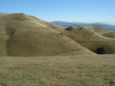 The trail along the backside of the ridge
- 0.0 mi: Start up the Tularcitos Trail toward Monument Peak.
- 0.2 mi: Turn left through the gate to get on the Agua Caliente Trail. You will go through several gates and cross a few roads on the way to the peak.
- 1.6 mi: Just after crossing Monument Peak Road turn right at the cattle drinking trough onto Monument Peak Trail. You will climb steeply for a bit. If you start descending you are going the wrong way! Continue on Monument Peak Trail all of the way up to the ridge.
- 3.7 mi: At the ridge, the trail turns to a gravel road. Continue straight on the gravel road past the radio tower and onto the Bay Area Ridge Trail toward Mission Peak. The trail gently rolls along the backside of the ridge all of the way to the peak.
- 5.8 mi: At Mission Peak summit! Enjoy the view, then retrace your steps back to the radio tower near Monument Peak.
- 7.9 mi: Back at the radio tower near Monument Peak. Instead of heading back down Monument Peak Trail, follow the signs to get onto Agua Caliente Trail. Get ready for some steep downhills and amazing views! You will follow the Agua Caliente Trail most of the way back to the trailhead.
- 11.0 mi: Confusing intersection! Cross Monument Peak Road and make sure to stay on Agua Caliente Trail!
- 12.3 mi: Agua Caliente Trail ends at Tularcitos Trail. Head through the gate and back to your car.
- 12.5 mi: Back at your car!!


