11/12(일요 Riding)Iron horse trail

1. 각자 집에서 출발점까지 왔다가
다시돌아감.
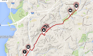
2.출발 점 8:30 AM Rudgear staging area ( Alamo//Danvile 중간)
3. 준비물 : 자전차
물
행동식 or 돈 or Credit Card
windbreaker, arm warmer, leg warmer, 장갑, mask
구급약/ 썬블락 로션
연락처 : (707)480-8867 kenn
4.참고
Iron Horse Regional Trail Facts
Iron Horse Regional Trail Description
 View Trail Map
The area surrounding the Iron Horse Regional Trail has an important history as part of the San Ramon Valley's agricultural and ranching past. Today, the Iron Horse Trail connects two counties and twelve cities. It runs through quiet residential neighborhoods, lively business and commercial districts and shady greenbelts. This popular and extensively used trail roughly follows Interstate 680, beginning in the city of Concord on its northern end and passing through Pleasant Hill, Walnut Creek, Alamo, Danville, San Ramon and Dublin before ending at the northeast edge of Pleasanton.
Plans call for the trail to be extended farther south to Stanley Boulevard in Pleasanton, where an existing bike trail leads east to Livermore. On the north end, there are plans to continue the trail to Suisun Bay in Martinez.
At the current northern end, the trail begins just south of State Route 4, near the northeast corner of Buchanan Field Airport in Concord. The trail nears the Pleasant Hill BART station at about mile 5. A rest stop across the street from the BART parking lot features picnic tables, a drinking fountain and benches. The northernmost part of the trail, as well as the proposed area around Suisun Bay, follows a marshy area, which is a haven for ducks and geese.
As you head south, the area becomes increasingly more urban, especially near downtown Walnut Creek. The Walnut Creek BART station is about a half mile off the trail here. Bicycle and pedestrian overpasses span Treat Boulevard near the Pleasant Hill BART and Ygnacio Valley Road in a congested section of Walnut Creek. South of Walnut Creek, the trail passes under I-680 at Rudgear Road to the west side of the freeway. A staging area here features parking, a drinking fountain, benches and tables.
From this point, the trail meanders through residential areas, crossing streets numerous times—though traffic is typically low—and offers easy access to restaurants and shopping. Much of the trail in this section includes a dirt running path adjacent to the asphalt bike trail.
In Danville, the trail passes directly behind the commercial downtown area. Nearby at the corner of Railroad and Prospect avenues is the old Southern Pacific Depot, which is the only original depot remaining on the line. Just past the depot is a pleasant area, featuring restaurants with outdoor seating overlooking the trail.
Picking up the trail again, you cross under I-680 to the east side and traverse Bishop Ranch Business Park, a commercial section that parallels the trail for about 2 miles. Next you reach the San Ramon Golf Club. The trail bisects the golf course, with chain-link fencing providing protection from errant golf balls. As the trail slices through Dublin, the environment is urban once more.
You next pass the Dublin/Pleasanton BART station and cross under I-580 before heading through some of Dublin and Pleasanton's dense housing and business development. The trail briefly leaves the former rail corridor at Arroyo Mocho and Santa Rita Road but picks it up again south of Stoneridge Drive. The final stretch runs in a wide corridor between fenced-in backyards before ending at Valley Avenue.
Parking and Trail Access
To reach the northern trailhead, take State Route 4 westbound to Arnold Industrial Way. Turn left onto Arnold Industrial Place and left again on Solano Way. Follow Solano Way and go under SR 4. Turn right onto Marsh Drive. The signed trailhead is on your left. Street parking is limited.
To reach the trailhead at the Dublin/Pleasanton BART station, exit Interstate 580 at Hopyard Road. Turn right on Hopyard Road and proceed for 0.3 mile. Turn right on Dublin Boulevard and go 0.5 mile. Turn right on Demarcus Boulevard, which leads to the station. The signed trailhead is at the north end of the parking lot.

-
Read MoreNo Image
3, 4 월 중요 일정 공지
3월 세째 주에 가기로 했던 Carrizo Plain NM 꽃 산행은 잠정적으로 4월 둘째 주로 연기 합니다. (그 곳의 올 겨울 강수량이 작년의 십분의 일 수준으로 현재 꽃... -
Read MoreNo Image
요세미티 Snowshoe Area Open!
지난 주에 눈이 많이 온 덕분에 드디어 Yosemite Ski & Snowshoe Area 가 제한적으로 오픈했네요. 오는 주말부터 (금 토 일에만) 4/1 주말 까지 snowshoe/cross-c... -
Read MoreNo Image
4/27 예약된 요세미티 Hogdon Meadow Group Campsite...
4/27 Group Site (30명), 4/28 Standard Site(8명) 가 현재까지 참가신청이 없네여. 저도 4월 중순(4/13~15)에 한번 요세미티 다녀올 예정이라 이건은 그렇게 땡... -
Read MoreNo Image
그랜드캐년 Backcountry Permit 받아셨요 5 26 일 5 27
NORTH RIM CAMPGROUND Grand Canyon National Park Site: 057 Fri May 25 2018 - Sat May 26 2018 (1 night)5 26 5 27 CBG BRIGHT ANGEL 캠핑장 아니면 아무데나 ... -
Read MoreNo Image
3~5월 Yosemite, Sequoia NP Hiking Plan
아직 Plan중인 단계라 정식 공지는 나중에 하고 관심있는분들 참가신청 먼저 받았으면 합니다. 3월 어느주말 or 5월18~20 Sequoia NP(Pear Lake & Alta Peak) -->... -
Read MoreNo Image
2/24 토요일 당일로 Yosemite four mile trail 갑니다
목요일날 눈 소식이 있습니다 . 요세미티 설경보러 2월 24일 토요일 당일로 four mile trail 갑니다 . 길 상태에 따라서 코스가 바뀔수도 있습니다 . 트레일 결정... -
Read MoreNo Image
JMT 한국어로 뮤어엉아길 20일 요세-위티니 하프톰 포...
어캐해서 뱓았서요 Trip details for your review: Permit ID: 02707 Entry Date: 07/21/2018 Entry Trailhead: Happy Isles->Little Yosemite Valley Exit Date:... -
Read MoreNo Image
어느 보험설계사의 인생스토리
어제 눈산행 가는길에 들어면서 갔는데 이야기가 너무 진솔하고 감동을 줘서 혼자 운전하면서 울다가 웃다가 했습니다. 관심있으신 분들 한번 들어보시길.. Files... -
Read MoreNo Image
2/17(토) 번개, Lake Alpine Sno Park
올해는 눈이 거의 없지 싶은데요. 작년 가족들과 Snow Play로 좋았던 기억이 있어 올해 한번더 가볼까 합니다. (눈이 있슴 있는대로 없으면 없는데로 이쁜 호수끼... -
Read MoreNo Image
2월 10일 토요산행.Olympia Peak Loop via Donner Cany...
좋은 하루입니다. 참석하신 분들에게 다운 받을 수 있는 링크 보내 드렸어요~~~ 용량이 커서 다운 받으시는데 좀 걸릴겁니다~~~ 느긋하게 기다리시면 됩니다~~~~ ... -
Read MoreNo Image
2/04/18(일요산행) Point Reyes NS - 산행 사진 공유
오늘 덕분에 즐겁고 행복한 산행이었습니다. 제가 찍은 사진들을 다운 받으실 분들은 이메일 주소를 문자나 메일로 보내 주시면 제 Google Drive 에서 다운 받을 ... -
Read MoreNo Image
독도 홍보영상...
독도가 우리 영토라는 외교부 홍보 영상입니다. 韓·日 외교당국이 펼친 인터넷 독도 동영상 홍보전에서 우리 측이 일본에 완승했다는 소식입니다. 대한민국 國民... -
Read MoreNo Image
산악회 재정 현황 (신년 기념 산행 지출 + 웹싸이트 써...
베이산악회 11차 운영위 재정 현황을 알려 드립니다. 1/13 반다나 (2) 추가 판매 ($20) 1월 13일 기준, 기금 총액: $1115.45 (기존 총액 $1,095.45 + $20) 1/20 ... -
Read MoreNo Image
1/20 토요 정기 산행 - 신년 떡국 산행
1월 20일, 다음주 토요 산행은 신년 기념 "떡국 산행"입니다. 떡국과 함껫 맛있는 바베큐도 준비한다고 합니다. 미리 귀띔을 해드리오니 다음 주 토욜일은 어디 ... -
Read MoreNo Image
Free admission coming to 40 California redwood stat...
Starting this Saturday and every second Saturday of the month for the rest of 2018, the public will be offered free vehicle admission to 40 of Californ...