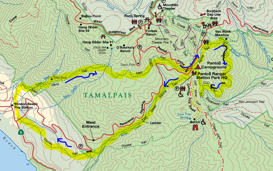
Mount Tamalpais를 올려봅니다.
Mt. Tamalpais SP
1393 Panoramic Highway
Mill Valley, CA 94941
예상 산행경로는 다음과 같습니다.
Steep Ravine --> Dipsea --> Matt Davis ---> Pantoll --> Alpine --> TCC---> Pantoll

PrevPrev Article
NextNext Article
ESCClose
| 산행지 | Steep Ravine Loop to Stinson Beach |
|---|---|
| 난이도 | Moderate (중간) |
| 예상거리 (mi) | 7.2 (Option: +2.8 Pantoll 에서 Alpine TR -> TCC TR 을 추가하면 총 10마일 정도가 될 수도 있음) |
| 고도변화 (ft) | 1600 |
| 예상 산행시간 (hr) | 5.0-6.5 hrs |
| 모이는 시간 및 장소 | Pantoll Campground @ 9:00AM |
| 산행 준비물 | 점심 및 간식, 충분한 양의 물 |
Mount Tamalpais를 올려봅니다.
Mt. Tamalpais SP
1393 Panoramic Highway
Mill Valley, CA 94941
예상 산행경로는 다음과 같습니다.
Steep Ravine --> Dipsea --> Matt Davis ---> Pantoll --> Alpine --> TCC---> Pantoll

 5/27 월요 번개 산행11
 5/25 (토) MT Madonna County Park36
 5/18/13 (토) : El Corte de Madera26
 05/11/2013(토) Black Diamond Mines Regional Preserve (Antioch)27
 5/4/2013 (토) Mt. Tamalpais26
 5월11일 토요일 요세미티 하프돔.15
 4/27 (토), 부정기, The Forest of Nisene Marks State Park38
 4/20 /13 (토) muir wood national mounment)39
 04/11 (목요산행) - Henry Cowell State Park, Fall Creek Unit10
 4/13/13 (토): China Hole - Henry W. Coe State Park66
 4/6/13 (토) : Del Valle Regional Park & Picnic112
 3/30(토) Almaden Quicksilver County Park33
 03/23 (토) 부정기- Castle Rock State Park27