. 본문 바로가기
부정기
2017.06.21 10:59

6/24/17 (토) Gap/Ridge Large Loop

조회 수 19062 댓글 2
?

단축키

Prev이전 문서

Next다음 문서

크게 작게 위로 아래로 게시글 수정 내역 댓글로 가기 인쇄 첨부
?

단축키

Prev이전 문서

Next다음 문서

크게 작게 위로 아래로 게시글 수정 내역 댓글로 가기 인쇄 첨부
Extra Form
산행지 6/24(토) Gap/Ridge Large Loop (13.0 mi, ~2300 feet elevation gain)
난이도 Moderate (중간)
예상거리 (mi) 13
고도변화 (ft) ~2300
예상 산행시간 (hr) 6
모이는 시간 및 장소 Saratoga Gap 주차장 ( 37.258327, -122.121298 ) @8:30 AM
산행 준비물 각자 본인의 점심 및 간식, 충분한 양의 물

다음주 원거리 산행이 있어 이번주는 근교산행을 하려고 합니다. 기회가 되면 한번 하려고 꼬불쳐둔 산행지 입니다.

아마 산악회에서도 같은 코스로 간적은 없지 싶습니다. 저도 구간별로 안가본데도 있구여.

여기 파킹랏이 MTB 바이커나 하이커들로 일찍 찰수 있습니다. 해서 산행시작 시간을 8시30분 으로 정했습니다.

참가 하실분이 안계심 더 일찍 할수도 있구여.


찾아 오는길 : https://goo.gl/maps/9vdhgpJXN9t


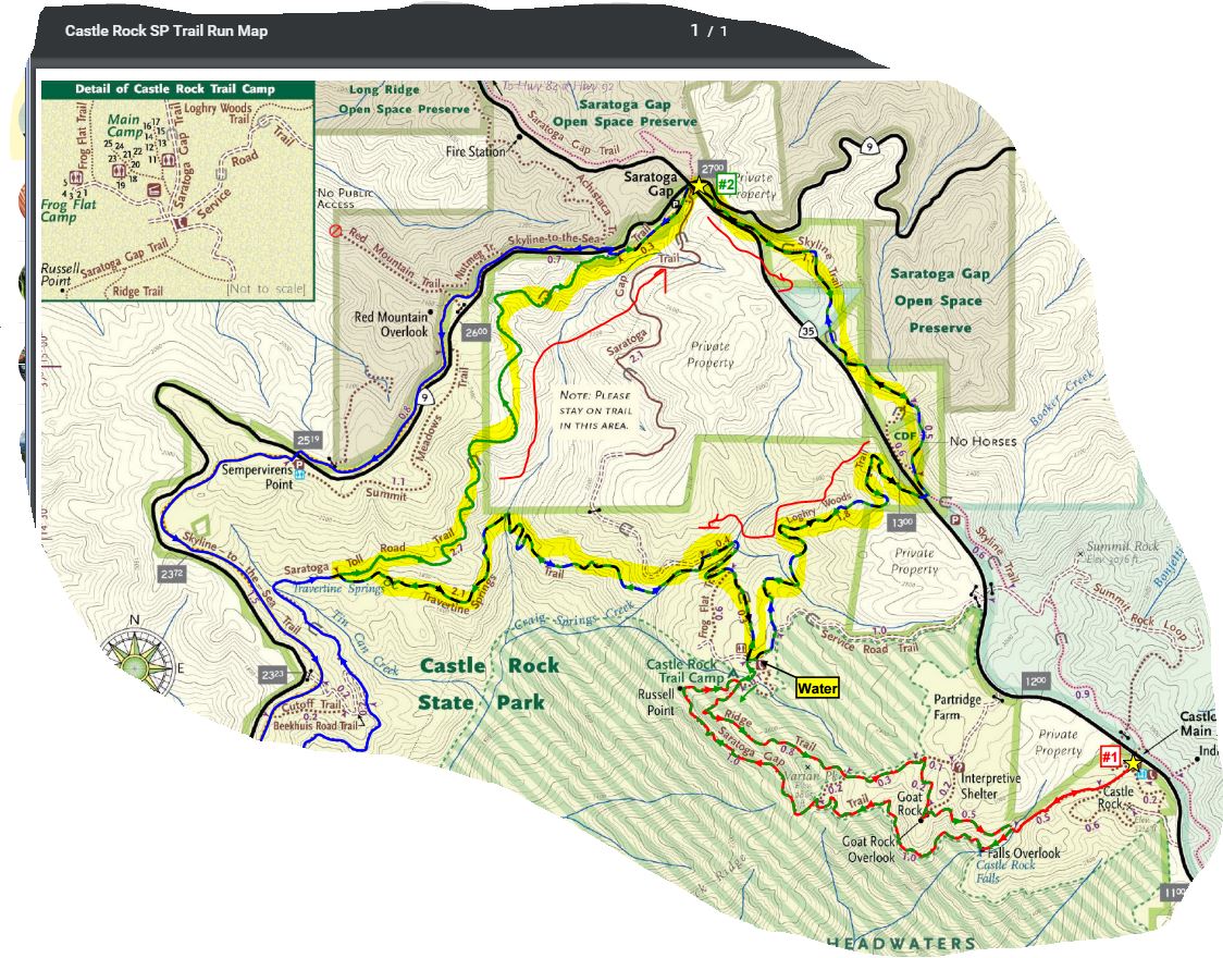
Favorite Run #2: Gap/Ridge Large Loop (13.0 mi, ~2300 feet elevation gain)

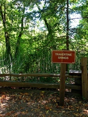
This loop is a challenging but beautiful run with some great climbing and excellent views. It incorporates the highlights of the previous run with a trip to Travertine Springs and a steady, moderate climb up Saratoga Toll Road. For this route we strongly recommend that you bring a trail map or download the GPX track to your GPS device, since some of the turns are confusing.  

This run starts at the Saratoga Gap parking lot. To start the run, head south on the Skyline trail, which begins at the southeast side of the parking lot (the side of the parking lot opposite from Hwy 9).

GPX Track

Printable Trail Map

Driving Directions
Route Details:
  • 0.0 mi: Start out on the Skyline Trail. The trail will climb for a bit and then flatten out.
  • 1.1 mi: Stay left on the "Pedestrians Only" trail.
  • 1.5 mi: (EASY TO MISS) The Skyline Trail will run near the shoulder of Skyline Blvd and intersect a driveway. At this point, cross over Skyline Blvd and get on the Loghry Woods Trail. (Note: It is very hard to see the Loghry Woods Trail, but you can tell when to cross because this is the first time that the Skyline trail runs along the shoulder of Skyline Blvd.) The Loghry Woods Trail is a fun singletrack descent.
  • 3.3 mi: Loghry Woods Trail ends on the Service Road Trail. Turn right toward the campground.
  • 3.4 mi: (WATER) At the Castle Rock Trail Camp. Get water if needed, then continue along the Service Road. Veer left slightly to stay on the road, and then turn right onto the first singletrack, which is the Saratoga Gap Trail. After climbing down a rocky section you will pass a few small trails on your left, but stay right to head toward the Ridge Trail.
  • 3.5 mi: Veer left to get on the Ridge Trail. You will climb for a mile or so.
  • 4.3 mi: Pass the Connector Trail on your right. Stay on the Ridge Trail.
  • 4.6 mi: Keep right to continue on the Ridge Trail toward Goat Rock.
  • 4.8 mi: At Goat Rock. Say 'hi' to the rock climbers, then continue down the steps on the Ridge Trail.
  • 5.3 mi: Intersection with the Saratoga Gap Trail.  Cross the stream and make a hard right turn onto the Saratoga Gap Trail.
  • 5.4 mi: At the falls overlook. Stop, admire the falls, then continue on Saratoga Gap Trail for two miles. You will pass the Connector Trail on your right, and then get ready for some great views! You will also pass a section where a cable has been installed as a handhold because the trail is narrow and tricky.
  • 7.3 mi: Intersection with the Ridge Trail. Stay left to continue back towards the Castle Rock Trail Camp.
  • 7.4 mi: (WATER) Back at Castle Rock Trail Camp. Get water if needed, then start heading downhill on the Saratoga Gap Trail towards Saratoga Gap (this is a wide fire road). After crossing a bridge, keep an eye out on your left for Travertine Springs Trail.
  • 8.1 mi: Turn left onto Travertine Springs Trail. This trail is a great singletrack that first descends to the San Lorenzo Creek and then climbs back up to Saratoga Toll Road with spectacular views along the way. (Interesting factoid: The tiny San Lorenzo Creek turns into the big San Lorenzo River which flows through Felton and finally empties into the ocean in Santa Cruz.)
  • 10.2 mi: Travertine Springs Trail ends. Turn right onto the historic Saratoga Toll Road and start climbing! You will climb for about three miles.
  • 12.6 mi: Pass Skyline-to-the-Sea Trail on your left. Continue climbing on the Saratoga Toll Road towards Saratoga Gap.
  • 12.9 mi: Saratoga Toll Road Trail ends at Highway 9. Turn right and run along the shoulder to get back to the parking lot.
  • 13.0 mi: Back at your car!

SaratogaGAP1.JPG


Skyline --> Logrywood --> Castle Rock Trail Camp --> Travertine Springs Trail --> Saratoga Toll Road Trail : (13Mi, 2300ft)
Picture
Travertine Springs Trail
Picture
Wait
https://www.alltrails.com/explore/map/skyline--240 (아마도 링크를 클릭하면 안보이실 겁니다. 아래 맵이...) 
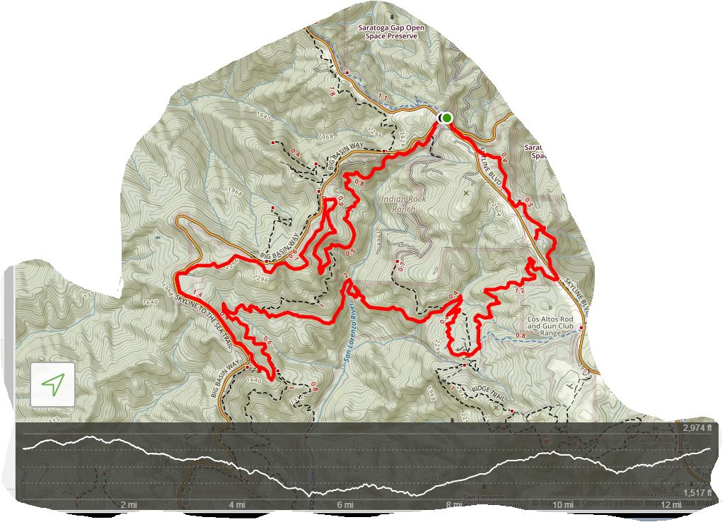
624HikingPlan.JPG


  • ?
    아리송 2017.06.21 12:42

    여기 코스가 다양해서 ~20마일정도의 그늘구간 골라서 산행하기에 참 좋습니다. 산호세 지역분들 한테는 접근성도 용이하고, 그늘도 많고, 파킹Fee도 없고..

    삼순이랑 참가 합니다.

  • ?
    아리송 2017.06.24 20:05
    토욜 아침! 갈까말까 고민하다 동네 평지트레일 3시간으로 땡. 여기는 담 기회에..

  1. No Image notice

    01/18/25(토) 정기산행 : Huddart 공원

    음식이나 기타 행사용 물품을 가지고 오시는 분들께서는 댓글로 알려주시면 감사하겠습니다. **** 식사 후 백패킹 세미나를 실시합니다. 세미나에 참여해주실 분...
    Category정기 ByFAB Reply43 Views182071
    read more
  2. 2015/5/23 (토) Sanborn County Park

    시원한 그늘이 많아, 여름에 맞는 코스입니다. 재작년 연초 겨울 산행중에는 산호세 베이 에리어 산행중 눈을 맞는 행운도 있었습니다. 도시에 가까우면서도 시원...
    Category부정기 ByKT Reply27 Views3418
    Read More
  3. 05/09/15(토) Point Bonita

    Point Bonita 앵콜요청이 들어와 이번주에 다시 갑니다 Clam Chowder도 다시한번 나갑니다~! 수지님표 클램차우더의 이미테이션입니다^^ 출첵마감 목요일 밤 8시...
    Category부정기 By두루 Reply11 Views4058
    Read More
  4. 5/8(금) - 5/10(일): 2박3일 캠핑 : GROVER HOT S...

    자연님이 타블렛이 고장이라고 캠핑안내를 좀 올려 달라고 전화로 부탁을 해서 제가 대신 올림니다........( 내 컴도 왕창 말썽이지만....) 참가 하실분들은 몇박...
    Category부정기 By아지랑 Reply40 Views4222 file
    Read More
  5. 4/25/15 (토) Marin Headlands - Point Bonita

    Marin Headlands 에 위치하고 아름다운 경관을 가지고 있는 Pt. Bonita 와 츠래일을 가려합니다. 베이산악회애서 처음가는 산행지입니다. 많은 참석 바랍니다. 찾...
    Category부정기 Bybear Reply37 Views3515 file
    Read More
  6. 4/25/15 (토) Henry Coe Backcountry 2015 Event

    산행날짜가 아직 2 주나 남았지만, 퍼밋 자리가 여유가 있어서 미리 알립니다. 한차당 인원수는 제한이 없고, 차는 퍼밋 하나당 차량 싸이즈에 상관없이 한대만 P...
    Category부정기 By아지랑 Reply52 Views3368 file
    Read More
  7. No Image

    4/11(토) Mt Diablo

    아래 싸이트에서 출발주소를 치면 2차 집결지까지 길안내가 나옵니다. 스마트폰이나 gps에 집결지 주소를 입력하면 잘 안내해 드릴 겁니다. 구글맵에서 한국마켓 ...
    Category부정기 By뫼산 Reply14 Views3565
    Read More
  8. 캔슬 되었습니다. 4/11 토: MT Madonna County Park

    오래간만에... 정말로 오래간만에 아싸가 산행안내 합니다. 2013년도 송년산행 이후에 한번도 가지 않았더군요. 만 16개월만에 다시 갑니다. 그러나 다른 트래일...
    Category부정기 By아싸 Reply7 Views3783 file
    Read More
  9. 3/28 (토) Morgan Territory

    지난 3/1(일)에 다녀온 곳입니다. Trail Route : Volvon >> Blue Oak >> Miwok >> Manzanita >> Valley View >> Volvon >> Eagle >> Highland Ridge >> Stone Cor...
    Category부정기 By계수나무 Reply40 Views3520
    Read More
  10. 3/14/15 Pescadero Creek CP

    이번 토요일엔 오랫만의 눈산행, Red Lake Peak 으로 있습니다만 눈산행에 참가하지 못하시는분들을 위해 로컬 산행공지 올립니다. 작년 2월22일 가서 많은분들이...
    Category부정기 BySooji Reply11 Views3046 file
    Read More
  11. 3월14일15년토요일 Red lake peak 눈산행.

    [2차 집결지] : Carson Pass Visitor Center 의 맞은편(남쪽 방향으로 조금 내려감)에서 9시에서 88번으로 오시는 분들은 Caples Lake 를 지나고 나서 4 miles 쯤...
    Category부정기 By산. Reply31 Views2864
    Read More
  12. 2/28 (토) Tomales Point Trail

    이번엔 순록들을 보고자 길벗님을 따라나서 봅니다 ;) 집결지 약도 입니다. 출발지 주소를 넣으시면 됩니다 찾아오는길 예상 산행도
    Category부정기 BySunbee Reply24 Views3692 file
    Read More
  13. 2/27(금)- 2/28/2015 (토) : 1박2일: 옛 광산도시 ...

    역사에 관심이 있으신 분이나, 관광을 좋아하시는 분들을 위해서, 이번 토요일날 산님께서 네바다 주에 있는 그 옛날 화려했던 광산도시 Virginia City 에서 Hist...
    Category부정기 By아지랑 Reply19 Views3104 file
    Read More
  14. 2/14/2015 Murietta Falls in Livermore

    헷갈리지 마시기 바랍니다. 이곳은 백팩킹이 아니고 당일 코스입니다. 우리의 동지들을 배웅할 겸 같은 날 같은 장소에 모여 같이 가다, 뮤리에타 폭포에서 헤어...
    Category부정기 ByKT Reply27 Views3547
    Read More
  15. 2/14-2/15/2015 - 1박2일 Ohlone Wilderness Trail

    작년 8월에 solo산행을 했던곳 입니다. (한명도 동참자가 없어서리 ..ㅠㅠ.) 이번에는 8명 예약했고, 일요산행 서노을을 즐겨찾던분들에게 같이 갑시다했더니 8명...
    Category부정기 BySunbee Reply33 Views3390 file
    Read More
  16. 1/31/2015 (토) Joseph D. Grant county park

    이 파킹랏은 프리이고 자전거를 타는 사람들과 나누어 쓰는 관계로 붐빕니다. 그리고 거리도 길어서 8:30분에 모입니다. 착오 없으시기 바랍니다. 힘든 코스는 아...
    Category부정기 By두루 Reply24 Views3098
    Read More
  17. 1/24/2015 (토) CM00ㅡEl Corte de Madera Creek OSP

    El Corte de Madera 가 오랬동안 공사하던 시설이 마무리 되어 작년 2 월에 Gate CM 00 가 새로 큰 주차장을 열었습니다. 이쪽 트레일은 그동안 파킹장 공사로 들...
    Category부정기 By아지랑 Reply40 Views4089 file
    Read More
  18. 1/10/2015 (토) : Rocky Ridge ㅡ LAS TRAMPAS RW

    Las Trampas 는 스페인어로 The Traps 라는 뜻 입니다. Trampas 라는 어원은 이곳에 살던 올로니 (Ohlone) 인디안들이 사냥할때에 사슴이나 노루를 깊은 계곡에 ...
    Category부정기 By아지랑 Reply78 Views4387 file
    Read More
  19. 12/27/2014 (토) Willson Camp _ Henry W. Coe State...

    베이 산악회에서는 처음 가는 트레일입니다. Hunting Hollow 입구 쪽에는 여러개의 트레일이 있습니다. 그 중 하나를 소개합니다. 트레일이 푸른 언덕을 끼고 올...
    Category부정기 By아지랑 Reply37 Views3578 file
    Read More
  20. 12/13/14 Joseph D. Grant County Park

    7마일 정도의 Loop은 풀이 많고 완만한 언덕에 간간히 서있는 Oak Tree를 지나며 오르락 내리락 하면서 확트인 Halls Valley 를 감상하실수 있습니다.
    Category부정기 By두루 Reply13 Views3486 file
    Read More
  21. 12/13/2014 (토): Sugarloaf Ridge State Park

    나파발리 서쪽에 위치한 또 하나의 유명한 와인 생산지인 소노마 지역에 있는 슈가로프 뤼지 주립 공원을 갑니다. ^+^ 크릭 ^+^ 산행후 옵션으로 [A] 바로 아랫 ...
    Category부정기 By아지랑 Reply21 Views3449 file
    Read More
목록
Board Pagination Prev 1 ... 25 26 27 28 29 30 31 32 33 34 ... 43 Next
/ 43
서버에 요청 중입니다. 잠시만 기다려 주십시오...

Sketchbook5, 스케치북5

Sketchbook5, 스케치북5

나눔글꼴 설치 안내


이 PC에는 나눔글꼴이 설치되어 있지 않습니다.

이 사이트를 나눔글꼴로 보기 위해서는
나눔글꼴을 설치해야 합니다.

나눔고딕 사이트로 가기

Sketchbook5, 스케치북5

Sketchbook5, 스케치북5