부정기
2017.06.21 10:59
6/24/17 (토) Gap/Ridge Large Loop
조회 수 21799 댓글 2
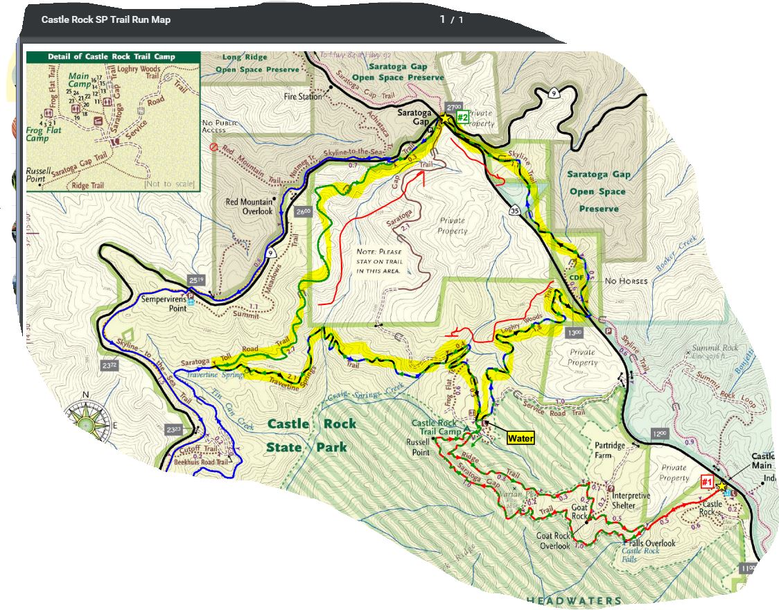
| 산행지 | 6/24(토) Gap/Ridge Large Loop (13.0 mi, ~2300 feet elevation gain) |
|---|---|
| 난이도 | Moderate (중간) |
| 예상거리 (mi) | 13 |
| 고도변화 (ft) | ~2300 |
| 예상 산행시간 (hr) | 6 |
| 모이는 시간 및 장소 | Saratoga Gap 주차장 ( 37.258327, -122.121298 ) @8:30 AM |
| 산행 준비물 | 각자 본인의 점심 및 간식, 충분한 양의 물 |
다음주 원거리 산행이 있어 이번주는 근교산행을 하려고 합니다. 기회가 되면 한번 하려고 꼬불쳐둔 산행지 입니다.
아마 산악회에서도 같은 코스로 간적은 없지 싶습니다. 저도 구간별로 안가본데도 있구여.
여기 파킹랏이 MTB 바이커나 하이커들로 일찍 찰수 있습니다. 해서 산행시작 시간을 8시30분 으로 정했습니다.
참가 하실분이 안계심 더 일찍 할수도 있구여.
찾아 오는길 : https://goo.gl/maps/9vdhgpJXN9t
Favorite Run #2: Gap/Ridge Large Loop (13.0 mi, ~2300 feet elevation gain)
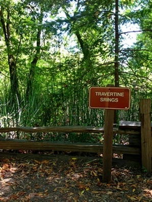
This loop is a challenging but beautiful run with some great climbing and excellent views. It incorporates the highlights of the previous run with a trip to Travertine Springs and a steady, moderate climb up Saratoga Toll Road. For this route we strongly recommend that you bring a trail map or download the GPX track to your GPS device, since some of the turns are confusing. This run starts at the Saratoga Gap parking lot. To start the run, head south on the Skyline trail, which begins at the southeast side of the parking lot (the side of the parking lot opposite from Hwy 9). GPX Track Printable Trail Map Driving Directions Route Details:
https://www.alltrails.com/explore/map/skyline--240 (아마도 링크를 클릭하면 안보이실 겁니다. 아래 맵이...) 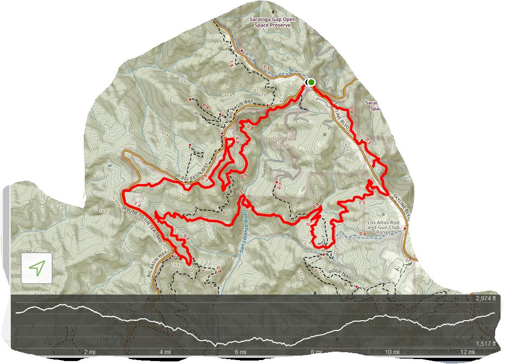 |
 6/24 (토) Redwoods Regional Park, Oakland
- ?
-
?
토욜 아침! 갈까말까 고민하다 동네 평지트레일 3시간으로 땡. 여기는 담 기회에..
-
read moreNo Image notice
7월 26일(토) Sunol Wilderness --- 정기산행입니다.
다함께 모이는 행사이므로 산행은 짧게, 뒷풀이는 길게 할 예정입니다. 정기산행이니 허다트 산행팀도 이 날은 정기산행으로 참석해주시면 감사하겠습니다. 캠핑... -
Read More

6/10/17 토요산행 Mt. Tamalpais (Old Mine- Bootjack...
무릎이 아픈 사람과 걸어도 무리가 없었던 코스로 정했습니다. 계곡의 물소리, 레드우드숲, 바다, 운무를 함께 보실 수 있는 산행지로 자연속에서 쉼을 얻고 싶으... -
Read More

6/17/2017 Del Valle Regional park (대표 총무 선거 -...
2주 전의 길벗님의 대표 총무 선거 산행 공지 링크를 여기 올려 드립니다. 산행을 참가하시는 분들은 아래를 클릭하셔서 Original 공지 페이지에서 신청 댓글을 ... -
Read More

6/24 (토) Redwoods Regional Park, Oakland
동행님을 대신하여 공지를 올려 드립니다. 더운 날씨를 감안해서 그늘이 있는 곳으로 산행지를 정했습니다. 지난 4월에 길벗님이 공지하실 때 쓰신 지도를 여기에... -
Read More

6/24/17 (토) Gap/Ridge Large Loop
다음주 원거리 산행이 있어 이번주는 근교산행을 하려고 합니다. 기회가 되면 한번 하려고 꼬불쳐둔 산행지 입니다. 아마 산악회에서도 같은 코스로 간적은 없지 ... -
Read MoreNo Image
6/30(금)~7/1(토) Convict Lake Camping
자유게시판에 공지한 내용이 밀려서 보이지 않는거 같아서 여기에 정식으로 공지 합니다. http://www.bayalpineclub.net/freeboard/545577 1. 준비물 – 일반 장거... -
Read More

7/4/2017(화)-4th of July Lake 산행
이번 4th of July(독립 기념일)에 4th of July Lake으로 산행을 가려고 합니다. 이곳엘 언젠가 가보려고 몇년 전부터 마음을 먹고 있었는데 기왕 가는 것 4th of ... -
Read More

(7/1/17, 다양한 정기, 토요산행) Purisima Creek Redw...
독립기념일 연휴입니다. 멀리 시에라 산맥으로 캠핑을 가지 못하시는 분들은 가까운 프리시마에서 시원한 태평양 바람을 맞으시기 바랍니다. 트레일 맵은 아래를 ... -
Read More

(7/8/2017, 토요 산행) Berry Creek Falls Trail in Bi...
오랜만에 빅 베이슨 팍에 있는 배리 크릭 폴 트레일로 갑니다. 지난 겨울 큰 비로 트레일의 여러곳이 손상되었는데 이제 대부분 복구가 되었나 봅니다. 빅 베이슨... -
Read More

7/15(토) 다정기 Portola Redwoods State Park (Old Pa...
11대 운영진이 주관하는 세 번째 산행, 무더위가 한창인 여름철을 맞아 지난 번에 이어 삼나무 숲에서 산행을 진행하겠습니다. 장소는 원시림으로 유명한 Portal ... -
Read More

7/15(토) Montara Mtn & San Pedro County Park
7월은 첫째 세째주 모두 다양한 정기인가 보지여? 아침에 볼일 좀 보고 약간 늦게 산행을 하려 합니다. 이번주 토욜도 90도 안팎의 무더위가 예상된다네여. 여기... -
Read More

7/22(토) 4 River Cross - Henry Cowell
다른 산행지도 함께 올려 주시고 안내 해 주시면 감사하겠습니다. 몇년전에 산동무님 안내로 가본곳인데 그냥 안내하는데로만 가서 정확하게 기억을 못합니다. 그... -
Read More

7/22(토) Sanborn County Park
안녕하세요. 7월 4째주 토요 산행입니다. 이번주는 다양한 토요산행공지가 여러개네요. 회원들이 본인 스케쥴과 취향에 맟출수있는 선택권이 많아 좋은거 갇습니... -
Read More

7/22(토) Lake Tahoe - Island & Twin Lake
A팀은 C(mt.price) 또는 D(mt.agassiz) 까지 등반하고 옵니다 B 지점에 클라스 3-4가 있으니 자신 없으신분은 우회하시면 됩니다. B팀은 A지점까지 갖다옵니다. ... -
Read More

(취소) 7/23(일) Land End To Golden Gate Bridge thru...
@@@@@@@@@ 이번 일요일이 샌프란시스코 마라톤이 있는 날입니다. 8만 인파가 모일거로 예상하네요. 이것도 확인못하고 덤벙되며 공지올려 죄송합니다. 이쪽지역은... -
Read MoreNo Image
7/28(금) Twin Lake Camping
꼭 아셔야 할 정보만 추려서 다시 정식 공지합니다. 캠핑은 같이 하고 하이킹은 각자의 형편에 따라서 몇 Group으로 나뉘어질 예정입니다. 7/29(토)하이킹 코스도...
여기 코스가 다양해서 ~20마일정도의 그늘구간 골라서 산행하기에 참 좋습니다. 산호세 지역분들 한테는 접근성도 용이하고, 그늘도 많고, 파킹Fee도 없고..
삼순이랑 참가 합니다.