본문 바로가기
부정기
2018.09.16 20:28

9/22/2018 (토) Gap/Ridge Large Loop

조회 수 1221 댓글 11
?

단축키

Prev이전 문서

Next다음 문서

크게 작게 위로 아래로 게시글 수정 내역 댓글로 가기 인쇄
?

단축키

Prev이전 문서

Next다음 문서

크게 작게 위로 아래로 게시글 수정 내역 댓글로 가기 인쇄
Extra Form
산행지 Gap/Ridge Large Loop
난이도 Moderate (중간)
예상거리 (mi) 13 mi
고도변화 (ft) 2300 ft
예상 산행시간 (hr) 6 시간
모이는 시간 및 장소 Saratoga Gap 주차장 ( 37.258327, -122.121298 ) @8:30 AM
산행 준비물 점심 및 간식, 충분한 양의 물

아리송님이 올리신 것을 참고했습니다.


여기 파킹랏이 MTB 바이커나 하이커들로 일찍 찰수 있습니다. 해서 산행시작 시간을 8시30분 으로 정했습니다.


찾아 오는길 : https://goo.gl/maps/9vdhgpJXN9t


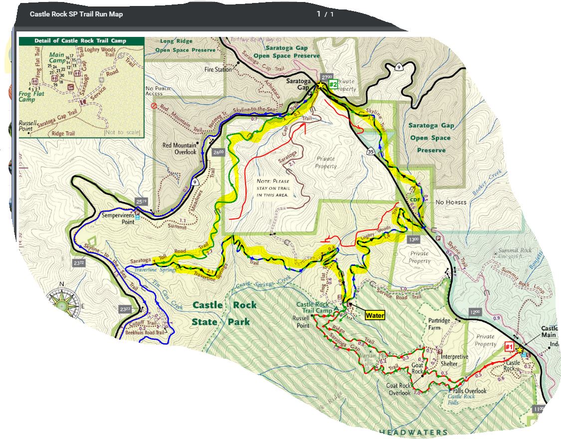
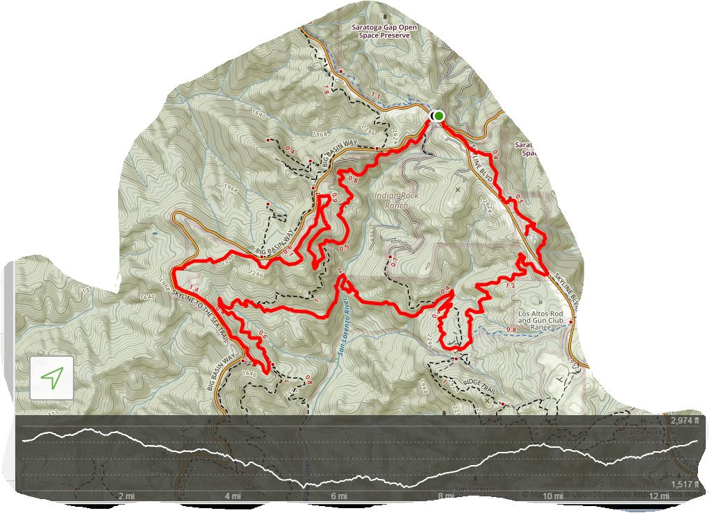
Favorite Run #2: Gap/Ridge Large Loop (13.0 mi, ~2300 feet elevation gain)

This loop is a challenging but beautiful run with some great climbing and excellent views. It incorporates the highlights of the previous run with a trip to Travertine Springs and a steady, moderate climb up Saratoga Toll Road. For this route we strongly recommend that you bring a trail map or download the GPX track to your GPS device, since some of the turns are confusing.  

This run starts at the Saratoga Gap parking lot. To start the run, head south on the Skyline trail, which begins at the southeast side of the parking lot (the side of the parking lot opposite from Hwy 9).

Route Details:
  • 0.0 mi: Start out on the Skyline Trail. The trail will climb for a bit and then flatten out.
  • 1.1 mi: Stay left on the "Pedestrians Only" trail.
  • 1.5 mi: (EASY TO MISS) The Skyline Trail will run near the shoulder of Skyline Blvd and intersect a driveway. At this point, cross over Skyline Blvd and get on the Loghry Woods Trail. (Note: It is very hard to see the Loghry Woods Trail, but you can tell when to cross because this is the first time that the Skyline trail runs along the shoulder of Skyline Blvd.) The Loghry Woods Trail is a fun singletrack descent.
  • 3.3 mi: Loghry Woods Trail ends on the Service Road Trail. Turn right toward the campground.
  • 3.4 mi: (WATER) At the Castle Rock Trail Camp. Get water if needed, then continue along the Service Road. Veer left slightly to stay on the road, and then turn right onto the first singletrack, which is the Saratoga Gap Trail. After climbing down a rocky section you will pass a few small trails on your left, but stay right to head toward the Ridge Trail.
  • 3.5 mi: Veer left to get on the Ridge Trail. You will climb for a mile or so.
  • 4.3 mi: Pass the Connector Trail on your right. Stay on the Ridge Trail.
  • 4.6 mi: Keep right to continue on the Ridge Trail toward Goat Rock.
  • 4.8 mi: At Goat Rock. Say 'hi' to the rock climbers, then continue down the steps on the Ridge Trail.
  • 5.3 mi: Intersection with the Saratoga Gap Trail.  Cross the stream and make a hard right turn onto the Saratoga Gap Trail.
  • 5.4 mi: At the falls overlook. Stop, admire the falls, then continue on Saratoga Gap Trail for two miles. You will pass the Connector Trail on your right, and then get ready for some great views! You will also pass a section where a cable has been installed as a handhold because the trail is narrow and tricky.
  • 7.3 mi: Intersection with the Ridge Trail. Stay left to continue back towards the Castle Rock Trail Camp.
  • 7.4 mi: (WATER) Back at Castle Rock Trail Camp. Get water if needed, then start heading downhill on the Saratoga Gap Trail towards Saratoga Gap (this is a wide fire road). After crossing a bridge, keep an eye out on your left for Travertine Springs Trail.
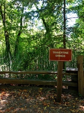
  • 8.1 mi: Turn left onto Travertine Springs Trail. This trail is a great singletrack that first descends to the San Lorenzo Creek and then climbs back up to Saratoga Toll Road with spectacular views along the way. (Interesting factoid: The tiny San Lorenzo Creek turns into the big San Lorenzo River which flows through Felton and finally empties into the ocean in Santa Cruz.)
  • 10.2 mi: Travertine Springs Trail ends. Turn right onto the historic Saratoga Toll Road and start climbing! You will climb for about three miles.
  • 12.6 mi: Pass Skyline-to-the-Sea Trail on your left. Continue climbing on the Saratoga Toll Road towards Saratoga Gap.
  • 12.9 mi: Saratoga Toll Road Trail ends at Highway 9. Turn right and run along the shoulder to get back to the parking lot.
  • 13.0 mi: Back at your car!

SaratogaGAP1.JPG


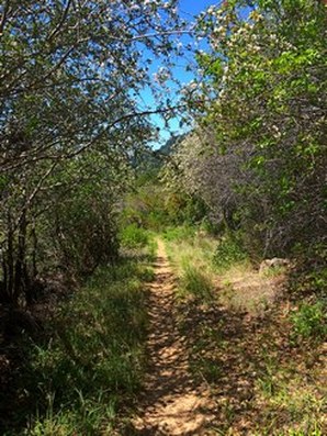
Skyline --> Logrywood --> Castle Rock Trail Camp --> Travertine Springs Trail --> Saratoga Toll Road Trail : (13Mi, 2300ft)
Picture
Travertine Springs Trail
Picture
Wait
https://www.alltrails.com/explore/map/skyline--240 (아마도 링크를 클릭하면 안보이실 겁니다. 아래 맵이...) 
624HikingPlan.JPG

  • profile
    창공 2018.09.18 12:58
    1번으로 참가합니다.
  • ?
    동행 2018.09.18 13:07
    반갑습니다
    추석이 다가오니 송편을 준비해야겠어요.^^
  • profile
    창공 2018.09.18 21:01
    아, 맞아요. 추석이 다가 오네요.
    송편 산행 기대 됩니다. ^^
  • ?
    Journey 2018.09.18 23:26
    Journey/미미 참가합니다.
  • ?
    두물차 2018.09.21 11:52
    참석합니다. 송편 먹으러~
  • ?
    동행 2018.09.21 12:43
    입하나 덜어도 되는데요...
    ㅎㅎ
    장난이예요
    맛난 배까지 준비해야겠네요~~
  • profile
    동사 2018.09.21 14:02
    송편 남는 거 그 다음 날 산행에 갖고 오실거죠?ㅎㅋ
  • ?
    동행 2018.09.21 14:05
  • profile
    동사 2018.09.21 17:01
    THX
  • ?
    동행 2018.09.21 19:18
    창공님,미미 져니님, 두물차님,부엉이 솔개님, 저 동행
    내일 뵙겠습니다.
  • ?
    솔개 2018.09.21 19:44
    솔개& 부엉이 참가합니다.
    26일 걷고도 아직 미련이 남는가 봅니다.

List of Articles
번호 분류 제목 글쓴이 조회 수 모이는 시간 및 장소
» 부정기 9/22/2018 (토) Gap/Ridge Large Loop 아리송님이 올리신 것을 참고했습니다. 여기 파킹랏이 MTB 바이커나 하이커들로 일찍 찰수 있습니다. 해서 산행시작 시간을 8시30분 으로 정했습니다. 찾아 오는... 11 동행 1221 Saratoga Gap 주차장 ( 37.258327, -122.121298 ) @8:30 AM
842 부정기 10/25/14 (산악자전거) 2nd Beginning Mountain Bike Ride We will be holding 2nd beginning mountain bike ride/class. We will be riding at different location this time around. We will meet at Grizzly Flat Trail... 21 자전거 1217 Grizzly Flat Trailhead parking @ 8:30 AM (22499 Skyline Blvd., Palo Alto)
841 부정기 6/13/2015 (Sat) Alum Rock Regional Park 안녕하십니까? 회원여러분! 여러분들의 관심속에 아들의 결혼식을 잘 마쳤습니다. 고마운 마음으로 소찬을 준비했으니 많은 회원들의 참석을 바랍니다. 산행은 오... 24 file bear 1215 Alum Rock 주차장 (Park 안으로 오셔서 제일 안쪽에 있는 주차장)
840 정기 3/4/23(토) 정기 산행 Castle Ridge Trail- Pleasanton 어느덧 3월 입니다 3월 첫주 정기 산행을 플레젠튼에 위치한 Castle Ridge Trail 8마일을 걸어 보려 합니다 현재 날씨예보는 변동이 있긴하나 흐린 날씨에 기온 5... 34 이장 1206 Parking lot, 3465 Old Foothill Rd, Pleasanton, CA 94588 @ 8:30AM
839 부정기 5/14(토) Alta Peak Alta Peak찾아가는길 저도 초행이라 많이 긴장되지만 FAB님께서 잘 Lead해주시리라 믿습니다. (580 경유해서 가는 경료) 101 S --> 152 E --> 99 S로 해서 가는 ... 93 file 아리송 1202 2차 집결지 주차장(Wolverton Parking Lot) @ 8:00 AM
838 부정기 1/9/16 (토) Alum Rock Park (North Rim Trail, Boccar... 이번주는 비가 몇차례 내릴거 같아요. 땅이 질벅하지 않는곳을 찾다 Alum Rock Park로 정했습니다. 나무가 많지 않은 Alum Rock Park 의 North 쪽으로 가봅니다. ... 36 file Sooji 1198 9:00 AM, 메인 파크입구 바로전 파킹장 (아래 참조 해주세요)
837 부정기 7월 5일 14년 토요일 Sam McDonald county park 아래 지도를 보면, 만나는 장소는 Sam McDonald County Park 입구가 아니라 계속 더 가서 Pescadero Road 에서 Alpine Road 쪽으로 직진. 약 1 마일 정도 들어가... 10 file 두루 1196 Heritage Grove 입구 주차장 @ 9:00 AM
836 부정기 12/13/14 Joseph D. Grant County Park 7마일 정도의 Loop은 풀이 많고 완만한 언덕에 간간히 서있는 Oak Tree를 지나며 오르락 내리락 하면서 확트인 Halls Valley 를 감상하실수 있습니다. 13 file 두루 1193 Mountain Hamilton Rd의 왼쪽편 Twin Gates parking lot 9:00 a.m.
835 부정기 (캠핑) Death Valley NP (4월 8일(금)~10일(일), 2박 3일) 1. 장소 – Death Valley National Park 2. 날짜 – 2016년 4월 8일 ~ 10일 (2박 3일) ***기온은 화씨 62~90도가 예상 됨. 3. 집결 장소와 시간: 1차 집결지 – 오전... 26 file 옐로스톤 1192 아래 참조
834 기타 1/25/15 (일) Sunol Regional Wilderness 서노을... 소나무님이랑 같이 다시 만나러 갑니다. 그녀가 궁금하신분은 같이갑시다.... 예상 산행경로입니다 (빨간선) 33 file Sunbee 1188 2차 집결지주차장 @9:00am
833 정기 정기산행, 8/5/2023, Sam Mcdonald Park 한 여름에 산행 하기 좋은 곳입니다. 수려한 레드우드의 진수를 맛보러 함께 가시죠. 찾아 오시는 길: https://goo.gl/maps/Dx1aPXVBHezkSZqz9 파킹피 $6 있습니... 36 file 동사 1187 @8:30AM; Sam Mcdonald Trailhead, 13435 Pescadero Creek Rd, Loma Mar, CA 94021
832 정기 12월 20일 2014년 (토) Pescadero Creek park 맨 처음에 갔던 트레일을 가보기로 하겠습니다. 이 게시물을... Pescadero Creek park.jpg (125.4KB)(4) ★ 2차 집결지 Tarwater Trailhead ♥ 2차 집결지_HWY35번... 29 계수나무 1182 2차 집결지 주차장 @ 9:00 AM
831 부정기 10/13/2018 이벤트 산행 (Redwood RP) 이벤트 산행을 많이 기다시셨죠? 드디어 10월 13일(토요일)이 다가옵니다. 이미 공지해 드린 바와 같이, 오랜 만에 같이 모여 산행도 하고 그간 충분히 나누지 못... 56 file 창공 1175 Canyon Meadow Staging Area 주차장 (Redwood Gate Area) 좌표: 37.806787, -122.148060 @ 09:00 AM
830 정기 6/04/22(토) 16대 첫 정기 산행 Long Ridge Open Preserve 2022년 새 회기의 첫 정기 산행을 개최합니다. 정기 산행인 만큼 많은 분들이 오셔서 인사도 나누고 자리도 같이 하는 시간이 됐으면 합니다. 특히 새로 가입하신... 31 file 창공 1174 Grizzly Flat Trailhead: 20455 Skyline Blvd, La Honda, CA 94020 좌표: 37.290618, -122.154385 @8:30 am
829 부정기 12월12일 토요일(부정기) Anthony Chabot Regional Park @: 2차 집결지 Trail Map: Horseshoe (0.08) -- Grass Valley (0.96) -- Redtail (1.29) -- Cottontail (0.55) -- Brandon (0.49) -- Escondido (1.39) -- Brando... 30 산. 1173 2차 집결지: Bort Meadow Staging Area (Anthony Chabot RP) @ 9:00 AM
목록
Board Pagination Prev 1 ... 32 33 34 35 36 37 38 39 40 41 ... 93 Next
/ 93