안녕하세요. Martin Luther King 연휴때, 백팩킹 가려고 합니다. 같이 가실 분 있으실까요?
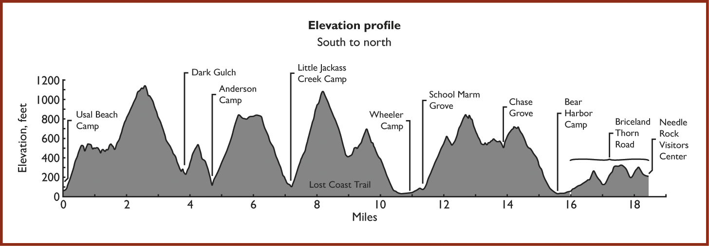
난이도: 7/10 (중급 이상)
저도 가보진 않았지만 쉬워 보이진 않습니다.
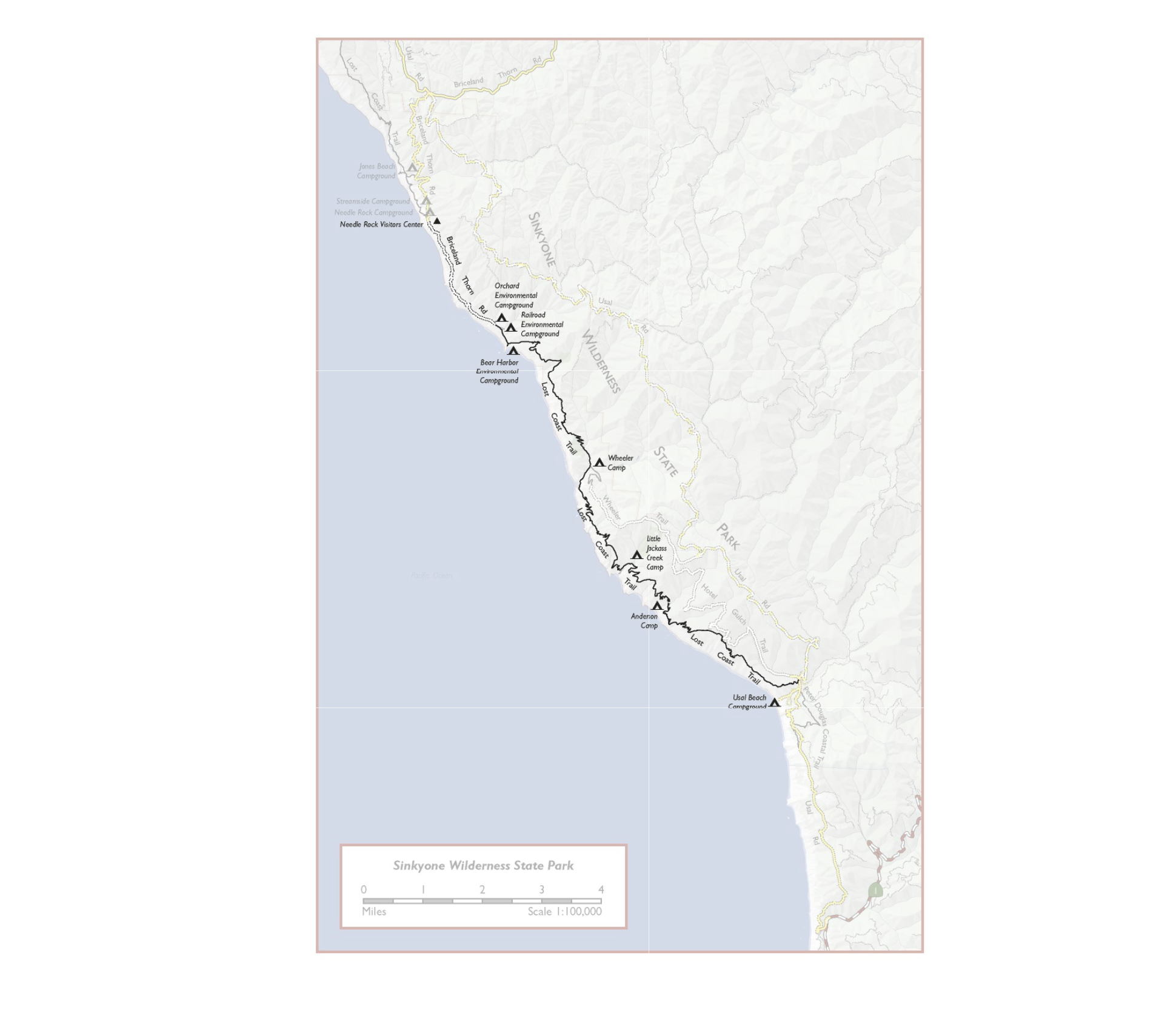
지역:Sinkyone Wilderness 지역
기간: 1/16 아침 부터 1/17 오후까지 (17일 밤에 집에 도착)
내용:
- Day 1 (1/15, 금): 개별이동(~ 5시간 소요), 산행 들머리에서 차박하거나 1/16 아침 8시까지 집결지에서 만남
- Day 2 (1/16, 토): 10~20 마일 산행후 dispersed/primitive camping ( 거리/ camping site TBD)
Campsite - Option 1: Jackass Camp, Option 2: Wheeler Camp Option 3: Bear Harbor Camp
- Day 3 (1/17, 일): 원점 복귀 후 귀가 ( Out & Back style)
만나는 시간/장소: 1/16 토요일 아침 8시 @ https://goo.gl/maps/Myivmwd1ao8f15LP9
Unpaved Usal Road YouTube :
https://www.youtube.com/watch?v=pnrY5ih4CfU
https://www.youtube.com/watch?v=EPPsHaKndro
관심 있으신 분 답글 달아주세요.
Covid 관계로 Carpool 은 각자 진행, 산행/캠핑은 같이 진행
YouTube: Sinkyone backpacking.
https://www.youtube.com/watch?v=3linlwJaeWU
https://www.youtube.com/watch?v=UnicPvrhzfg
https://www.youtube.com/watch?v=9l9dC97LIT8
Gaia GPS:
https://www.gaiagps.com/datasummary/track/ebf86eb7190642f357d8c53a2bbfa523/
AllTrails:
https://www.alltrails.com/explore/trail/us/california/lost-coast-trail-usal-to-wheeler-camp?mobileMap=false&ref=sidebar-static-map&ref=sidebar-view-full-map
https://www.parks.ca.gov/?page_id=429
http://www.redwoodhikes.com/Sinkyone/LostCoast.html
http://www.redwoodhikes.com/Sinkyone/WheelerTrail.html
Some useful reviews:
Usal Beach to Little Jackass Creek (7.2 mi, 2320 ft)
The length of this section is misleading; it feels more like 10 miles and will take at least as long as a typical 10-mile hike.
The trail begins at the Usal Beach campground, named for the USA Lumber Company, which built a sawmill here in 1889.
The campground doesn’t take reservations and doesn’t even have defined campsites, but there always seem to be spots available. Despite its remoteness, the large campground is very popular and can be a bit of a zoo on summer weekends, with cars constantly driving by on the dusty roads and radios blaring. There are no park rangers or any other staff present, and I’ve heard that people illegally off-road on the beach, set off fireworks, and even shoot guns late into the night. Fortunately, all of this is left behind within the first mile of the hike.
The trail begins with a climb along an attractive redwood-covered ridge. About a half-mile in is a brief break in the woods with a nice viewpoint. There’s a little up-and-down as the trail continues through woods and open coastal scrub.
At mile 1.5 the trail begins a steep and unpleasantly brush-clogged climb up an exposed hillside. This is the worst brushy section of the entire trail; it continues for about a mile but feels never-ending. It’s a relief when the trail finally enters the woods again, where it becomes blissfully wide and clear (if I’m doing an out-and back, on the way back I’ll usually cut over to the dirt road at this point so that I can skip all the brush). The descent into Dark Gulch is mostly clear and easy; at one point there’s an attactive little patch of old-growth redwoods, with 3 or 4 medium-sized trees visible from the trail.
The crossing of Dark Gulch, including the last few descending switchbacks and the first few ascending switchbacks, is by far the most heavily-eroded part of the trail. The loose, sandy soils within the remarkably steep-sided canyon have resulted in steep, sandy up-and-downs, slumped trails, and dangerously narrowed hillside cuts. It’s quite a slow and unpleasant half-mile.
Hiker A
Hiked the southern Lost Coast Trail (Sinkyone Wilderness) with my son in early July 2018. Stared at Hidden Valley, out at Usal beach 3 days and 3 nights on the trail. Many beautiful sections on the trail, especially the tracks through the redwoods and near the coast (jones beach to bear harbor especially.) Sections through the dry, exposed tall grass and scrub sections were VERY challenging. Impossible without poles. Trail has collapsed in many sections. Lots of trees across the trail in higher sections. Lower sections overgrown with nettles & thorns. No trail maintenance in many years. Recommend long pants and long sleeves and gloves and boot traction covers (seriously!). Sinkyone VERY different from Kings Range section. Multiple 1000 ft plus elevation gains and losses. More time in the redwoods, very little on the beach. But ample rewards for the adventurous and prepared! Relatively few hikers on the trail. No problem finding nice campsites at backcountry sites. No problem with water at stream crossings. Lots of Elk, especially at Jones beach. No evidence of bears. In summary, a challenging AND rewarding hike. Not for newbies or unprepared. 3 full days recommended for full southern section.
Hiker B
I have to agree with the comment of "what trail?" Of course the views are spectacular, the wildlife was awesome, we did see a bear which is ALWAYS an awesome sight, but the Poison Oak, the Stinging Nettle EVERYWHERE, Manzanita overgrown, VERY brambly, some of the trail is completely washed out so it's a bit tricky not to slide down the side if you're not extremely careful! A few HUGE downed trees that you have to climb over or under (pain in the butt with a backpack!)
Once we got to Jackass Creek, we saw that an outhouse had been washed away down the creek (with potty in toe). There was also a bridge that was no longer, just the remanence of it. We decided to follow the creek in order to access the ocean hoping for a place to stay the night and BAM there it was and it was AMAZING! It was no easy task getting through all the obstacles but we made it and it was well worth it. Be aware that there is a bear living nearby this gorgeous "site" but we left each other alone! :) It's a difficult trek all in all with so many things to deal with. Having said that, I would not do this again unless it was "maintained" again. If you do decide to take the challenge, WEAR LONG PANTS AND LONG SLEEVES!!!!!!!!!!!!


 [장거리 캠핑]Alabama hills 2/5(금) ~ 2/6(토)
 번개 장거리 Telescope & Cottonwood Canyon Loop


여기 1박 2일도 가능하지 않을까요? 눈산행말고 따뜻한 북쪽으로 꼬부라질까요 ?